Atmospheric disturbances from the midlatitudes appear to derail the Indian summer monsoon
Nearly half of the droughts during the Indian summer monsoon in the past century may have been driven by atmospheric disturbances from the North Atlantic region, finds a new study published in Science. It was conducted by researchers at the Centre for Atmospheric and Oceanic Sciences (CAOS).
More than a billion people in the Indian subcontinent depend on the annual summer monsoon, which brings copious rain to large swathes of the country between June and September.
When it fails, and most of the country is plunged into drought, the usual suspect is El Niño, a recurring climate event during which abnormally warm equatorial Pacific waters pull moisture-laden clouds away from the subcontinent. But 10 out of 23 droughts in India in the past century occurred during years when El Niño was absent. What, then, could have caused them?
The IISc study shows that these droughts were a consequence of a sudden and steep drop in rainfall in late August. This drop was linked to an atmospheric disturbance in the midlatitude region over the North Atlantic Ocean, creating a pattern of atmospheric currents that swoop in over the subcontinent and “derail” the monsoon.
“As early as the 1980s, people have looked at these droughts individually. But they have not collated and pooled them together, and deduced that these droughts may all have a different type of evolution than El Niño droughts, as well as a common cause, which is this midlatitude influence,” says V Venugopal, Associate Professor at CAOS and a senior author.
The research team looked closely at daily rainfall during both El Niño and non-El Niño drought years, and noticed stark differences in the patterns between June and September. El Niño droughts follow a standard pattern. The rainfall deficit – departure from a long-term average – sets in around mid-June and becomes progressively worse. By mid-August, the deficit spreads across the country and a drought is inevitable.
Surprisingly, the non-El Niño droughts, when analysed together, also seemed to follow a common pattern. First, there was a moderate slump in June. Then, during mid-July to mid-August, the monsoon showed signs of recovery and rainfall increased. However, around the third week of August, there was a sudden steep decline in rainfall, resulting in drought conditions.
“The question was: why does the break occur this late in August?” says Jai Sukhatme, Associate Professor at CAOS and another author. “We tried to see if we could trace it back to a forcing agent or system that influences the behaviour over India. We looked at the winds that were prevalent in these non-El Niño drought years.”
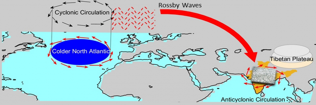
That was when they noticed an unusual midlatitude disturbance, which emerged from winds in the upper atmosphere interacting with a deep cyclonic circulation above abnormally cold North Atlantic waters. The resulting wave of air currents, called a Rossby wave, curved down from the North Atlantic – squeezed in by the Tibetan plateau – and hit the Indian subcontinent around mid-August, suppressing rainfall and throwing off the monsoon trying to recover from the June slump. The wave’s usual course is to go from west to east, but not towards the equator, explains Sukhatme. “This inward curving was the peculiar thing that we noticed during these particular years.”
The findings underscore the importance of also considering influences on the Indian monsoon from outside the tropics, which current forecast models focus heavily on. “The Indian Ocean and Pacific Ocean seem to be at the forefront of all discussions surrounding Indian monsoon droughts,” says Venugopal. “It is perhaps time to focus just as much on midlatitude influences, which might aid in getting a better handle on enhanced predictability of monsoon variability.”


